Overlook on Bear Creek
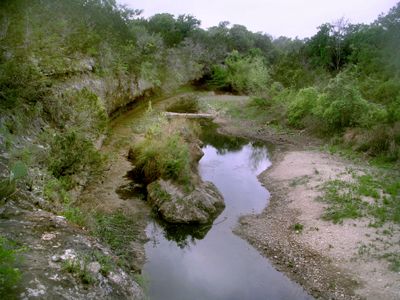
April, 2013
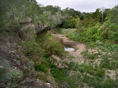
September, 2013
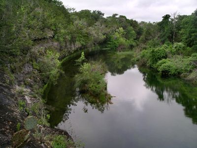
April, 2015
Overlook on Bear Creek April, 2013 |
September, 2013 |
April, 2015 |
Back to the basis for the low-water crossings. Much of our terrain here is rocky. Also, it doesn't rain a little bit at a time on a regular basis. In fact, it is much more likely to be perfectly dry for months and then comes a deluge. Flash floods are the norm. I tend to like water and when I first moved here I found the desiccated condition of the creeks very depressing. Day after day of sunshine and hot weather took quite awhile to get used to.
Well, now I am comfortable with our boom-and-bust hydrological situation. In fact, it is quite interesting, and sometimes even dramatic. Unlike tornadoes or fires, which can occur almost anywhere, floods are pretty darn predictable. They always occur in the aptly named flood plains of streams and rivers. If an area has ever, even a long time ago, had a lot of water covering it, the same thing can happen again, and buildings, even houses, are not a deterrent.
About six years ago I started taking hikes on a property owned by the City of Austin as part of their Water Quality Protection Lands program. The program, which manages more than 25,000 acres, protects land that is over the Edwards Aquifer recharge zone from development. I was invited to help survey vegetation on the 2,000 acre section called, simply, Onion Creek. As expected, that creek does run through the tract. For months, I helped with finding and identifying plants, as well as seeding burn areas and assisting a friend when he taught grass identification classes. There is a program of public hikes on the properties and I eventually became a hike guide specializing in insects.
I enjoyed seeing Onion Creek at different times of the year and in different stages of hydration. There were periods when the stream bed had no water at all and we walked in it. At other times, it was a picture-perfect rippling waterway. I still occasionally lead hikes on that property, but starting three years ago, I was introduced to another tract. This one is called Tabor, after the name inscribed in the concrete of a dam on Bear Creek, which is the centerpiece of the 300 acre site. Bear Creek is a tributary of Onion Creek and the two streams meet under the appropriately named Twin Creeks Road. This road has a pair of REAL bridges, not just low-water crossings, as there is usually water in both beds. Both bridges are tall, about 25 feet above steep-sided brooks. I drive over them once a week when I visit a friend and it is fun to note the relative water flows as I cross.
While Onion Creek is fairly scenic, Bear Creek is absolutely stunning. A long overhang cave skirts one of the bends in the stream. There is a perfect high point from which to view and photograph it. The dam creates a lake that extends up into this region. Depending on how much water is behind the dam, the stream bed can be almost all dry or completely filled. One of the more interesting aspects of visiting both Onion and Tabor is that sometimes the two creeks do not match in water level. Depending on which watershed receives small downpours, one might have water while the other is dry, or sometimes both are dry or both are flowing.
The summer of 2013 was an exceptionally dry year here in Austin. The segment of Onion Creek that I visit was completely dry and most of Bear Creek was too. In the spring, there was still a reasonable amount of water above the Bear Creek dam, but by autumn, there were only a few pools left. I was able to take hikers down into the creek bed, which sported nice stands of wildflowers in the gravel, and we sometimes caught a glimpse of the huge resident snapping turtle that commandeered the deepest pool.
Then, in late October, 2013, we had a major flood event. On Wed. and Thurs., Oct. 30 and 31, it rained. A lot. The precipitation was fairly widespread and some spots got up to 14 inches. There was a lot of flooding. I didn't pay too much attention to the news, though, and on Fri., the weather was clear again and I headed down south to Manchaca to visit my friend. When I turned down Twin Creeks Road, there was a sign off to the side saying the road was closed. I thought it was probably left from the previous day when the water might have gotten pretty high, so I drove on down. As I approached the bridges, it was certainly obvious that the road really was closed. It had washed away on one side of the Onion Creek bridge. I parked and went to get a closer look. There were trees and other debris on the bridge and a big gaping hole where the road used to be. The water in the stream was high but nowhere near the height of the bridge. Next to the damage and police barriers, someone had sarcastically posted one of the Stage III Critical Drought signs warning residents to stop outdoor irrigation.
After trying another road, which was also closed due to debris, I finally took the interstate highway to get across. My friend lives well above the flood plain, so there was no damage in her neighborhood. With unusual efficiency, the roads were restored in only a week. While the widespread drought has continued, that memorable flood was quite a dramatic punctuation. During the remainder of 2013 and the next year, when I took groups out to see Onion Creek, we always stood by the water and looked up in awe at the debris in trees, 25 feet over our heads! The vegetation on the bank that had been underwater was at first completely flattened, but, over the months, recovered and grew back as if after a fire.
Now, in 2015, we are having an El Nino assisted wet weather pattern and are getting ample rain, albeit downstream from the Colorado River reservoirs that provide Austin's municipal water supply. The Tabor property looks like a well-watered rock garden and Bear Creek is the highest I've seen. Not only is the dam reservoir completely filled, but a torrent flows over the top in a 50-foot wide roaring waterfall. From my favorite vantage point overlooking the water, it is hard to imagine, but all too inevitable, that, when the rains stop, the water will once again disappear.